Free UK detecting app

Don't just detect the land. Understand it.

Understand your permission before you step into the field.

FieldGuide reads the landscape so you can understand your permission before the first swing. Record finds, protect permissions and build a better understanding with every visit — all privately on your own device.

Installs to your home screen in two taps · No app store · No account · No subscriptions

FindSpot FieldGuide hotspot card showing evidence for a stronger starting point
FieldGuide context Landscape evidence, nearby signals and recorded history brought together before you search.
5,000+ detectorists
Free to use
No account
Offline recording
Private by default

The detailed field reports have helped me build a very good relationship with the council — and even secure a couple more areas to detect on.

Lee W. — council park permission

Four field jobs. One app.

FindSpot is arranged around the jobs detectorists actually do before, during and after a dig.

1
Scan land

Understand the landscape first

FieldGuide compares terrain, water, historic routes and landscape context to surface stronger starting points.

2
Record finds

Log quickly, finish properly

Capture GPS in the field, then add photos, material, period, depth, detector data and notes when you have time.

3
Manage land

Protect your permissions

Keep boundaries, proof, agreements, landowner details, coverage and visit reports together.

4
Plan digs

Clubs, rallies and days out

Find nearby events, mark yourself as going, or run a QR-based club day with a combined review.

Less guessing. More understanding.

FindSpot is not just a finds notebook. It connects the place, the search, the permission and the record.

Landscape

Evidence before the first signal

Terrain shape, water, old routes and protected-area awareness help you choose where to start.

Field use

Fast enough for muddy hands

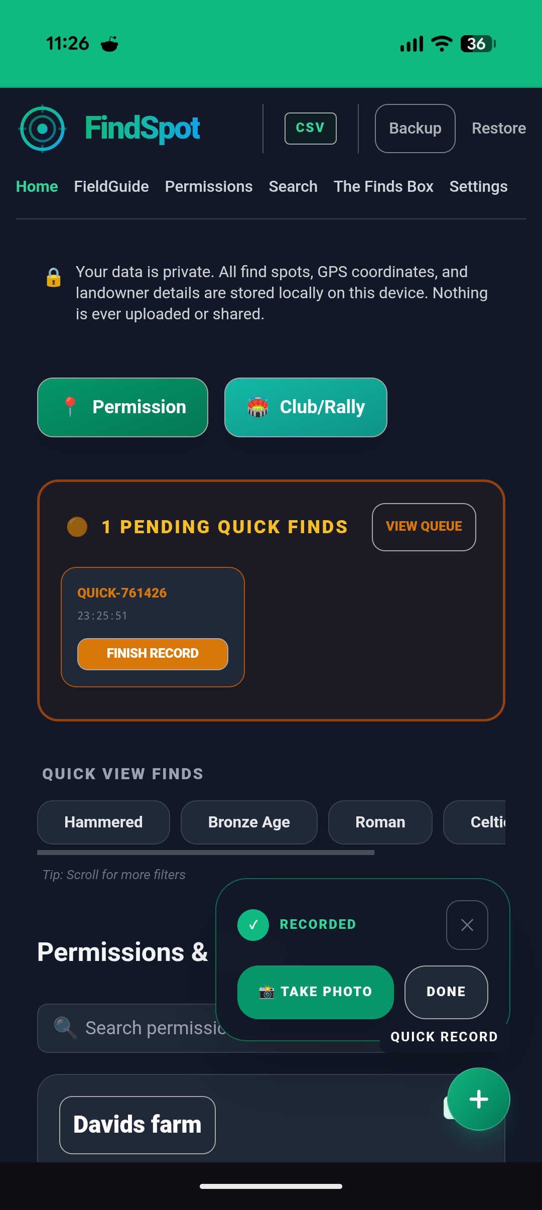
Quick capture records the location immediately, then lets you complete the record later.

Landowners

Proof and reports in one place

Show permission, track coverage and produce field visit reports landowners can understand.

Responsibility

Guidance when context matters

Significant-find workflows help preserve spatial context before details are lost.

Understand your permission before you arrive.

FieldGuide reads terrain, water, routes, historic mapping and recorded archaeology to highlight where past activity is more plausible — and shows you the evidence behind every interpretation.

  • Shows its workingEvery scan explains itself: what supports the interpretation, what weighs against it, and how confident it is.
  • Checked against half a million recorded findsPortable Antiquities Scheme data means the recorded history of the wider landscape counts as evidence.
  • Reads terrain, water and lost routesSurface shape, hydrology and vanished tracks from historic Ordnance Survey mapping are strongest when they point to the same place.
  • Includes protected landscape awarenessScheduled monument boundaries are visible before you are standing on them.

FieldGuide highlights potential and helps focus your search. It does not guarantee finds.

Every permission has a story.

Two views of the same field — one plain, one with FieldGuide's landscape evidence layered in.

Plain field view
A plain field scan showing an isolated target without broader landscape context
FieldGuide context
A FieldGuide hotspot card showing multiple signals supporting the same location

Your own recorded finds become evidence in FieldGuide. Scans near your finds weigh them against the wider recorded landscape — so the more you record, the sharper your interpretations get.

Mud, rain, gloves on. Still works.

FindSpot is built for quick decisions in the field and fuller records when you are back at the car or home.

  • One-tap Quick FindCapture GPS instantly so you never lose the find spot, then complete the details later.
  • Coverage trackingSee where you have walked and where you haven’t.
  • Offline firstRecording, permissions and field tracking work without signal.
FindSpot quick capture interface for recording a find in the field
Quick capture Record the point first. Add the full find details when it is practical.
FindSpot find record card with photos and find metadata
Find records Location, depth, material, period, detector context and photos in one structured record.

Your finds deserve better than a notebook.

Every find can become a useful record, not just a memory tied to a photo roll or a paper note.

Archaeological-quality fields

Keep grid position, material, depth, period and context together.

Detector metrics

Store target ID, signal notes and detection context with the find.

Shareable cards

Generate clean find cards for club sharing, landowner updates or reporting support.

Significant finds

Use guided routes when a discovery needs more care than a standard record.

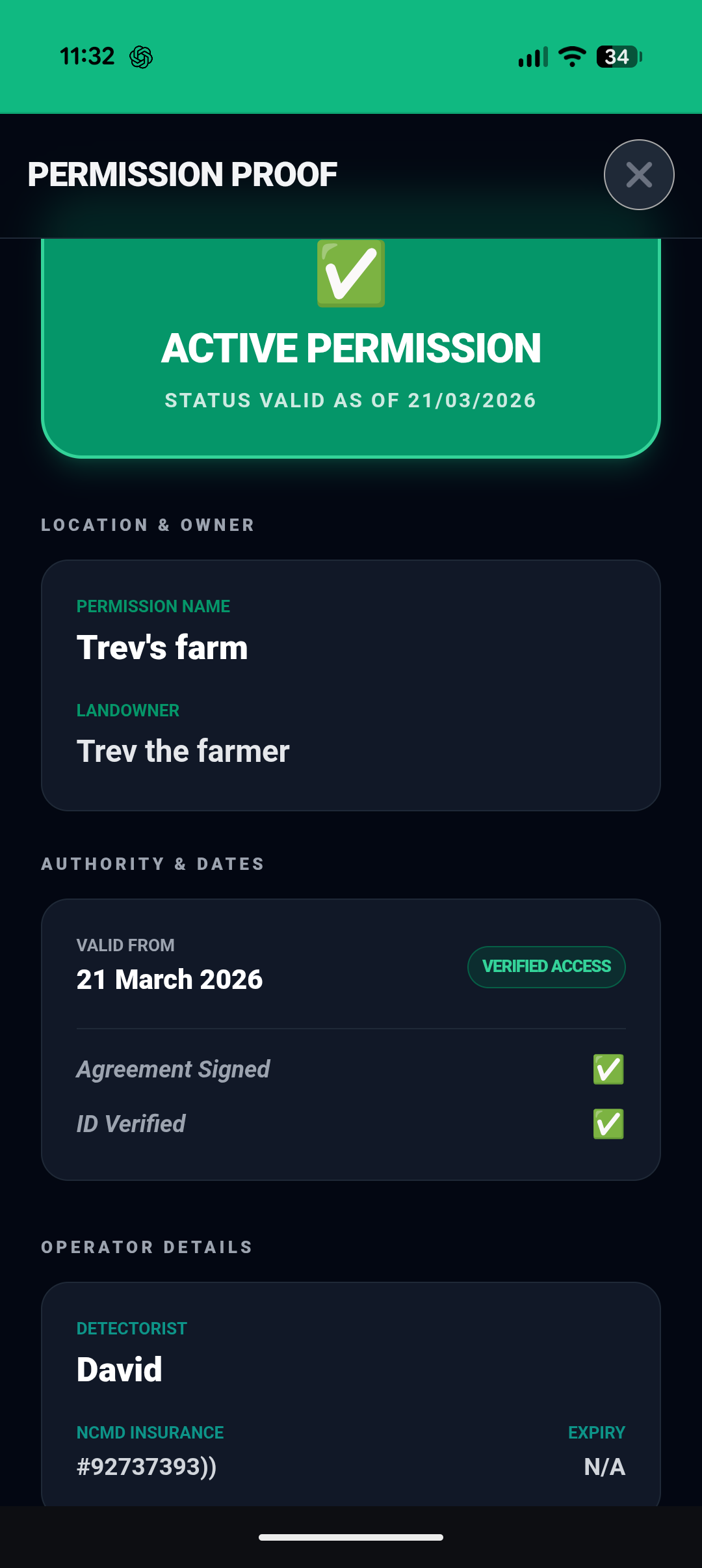
FindSpot digital permission proof screen
Permission proof Clear information when you need to show you are allowed to be there.

Protect your permissions. Earn more land.

Professional landowner management, from first contact to field visit reports.

  • Proof of permissionShow a clear digital permission screen if challenged in the field.
  • Agreements and boundariesKeep landowner details, signed agreements and mapped fields together.
  • Field visit reportsSummarise time on site, area covered and finds recorded for the person who gave permission.

When context matters, choose the right route.

Some moments in the field need more than a normal find record. FindSpot keeps the next step clear.

Stop & Secure

Something may still be in the ground

Stop digging, protect the spot, record the position and preserve context before further disturbance.

Map Scatter

Finds spread across an area

Log each point before the pattern is lost and build a clearer picture of the scatter.

Notable Find

One exceptional object recovered

Record photos, location, context and follow-up details before they are forgotten.

Supports responsible recording. Does not constitute legal or reporting advice.

Run a club or rally dig without the admin.

One QR code, no accounts, no installs, and a combined review when the day is done.

Organisers

Create the dig

Share a single QR code and import members' finds into a full day review.

Members

Scan and record

Join quickly, record finds and export the session to the organiser in one tap.

Discover

Find local events

Browse clubs, rallies and club digs filtered to your area, then plan the session.

Just recording your own day at a club dig or rally? A personal dig record needs no organiser, no join link — and shares nothing.

Your data stays yours. Always.

Saved finds, GPS coordinates, photos, permissions and landowner details stay on this device unless you choose to export, share or submit them.

Local-firstYour private records are stored in your device's own database.
No automatic uploadsFinds are not synced to a FindSpot account in the background.
No location analyticsNo advertising trackers or analytics on saved find spots, tracks or permissions.
Export controlExport records as CSV or JSON whenever you need a copy.

No subscriptions.
No accounts.
No locked features.

Everything. Free. Always.

Common questions

Everything you need to know before you install.

Does it work on iPhone and Android?

Yes. FindSpot is a Progressive Web App, so it works in a modern phone browser. On iPhone, open it in Safari and use Add to Home Screen. On Android, your browser will usually offer to install it.

Do I need to create an account?

No. There is no account, login or email required. You can start using FindSpot immediately.

Does it use mobile data in the field?

Find recording, permission management and coverage tracking work offline. FieldGuide needs a connection to fetch landscape data for a new area, but loaded results and map tiles can be cached.

Is it really free?

Yes. FindSpot is free to use in full, with no subscription, locked tier or account requirement.

What is FieldGuide?

FieldGuide is FindSpot's landscape intelligence engine. It analyses terrain, water features, historic routes and recorded archaeology — including Portable Antiquities Scheme data and your own recorded finds — and shows the evidence for and against every interpretation. It helps focus a search, but it does not guarantee finds.

What if I find something important?

FindSpot includes guided workflows for Stop & Secure, Map Scatter and Notable Find records. They help preserve context and support responsible recording, but they do not replace professional or legal advice.
Don't just detect the land. Understand it.

Open FindSpot on your phone and keep FieldGuide, finds, permissions and club days in one local-first workspace.

Open FindSpot free